Most major droughts in the U.S. occur after many volcanoes erupt each year
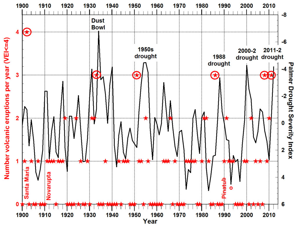
Four out of the five major droughts since 1900 occurred within one to two years following a year in which 3 or 4 volcanic eruptions occurred. The three largest eruptions (Santa Maria, Novarupta, and Pinatubo, labeled in red) had Volcano Explosivity Indecies (VEI) of 6. Eight eruptions were VEI=5. The remaining 70 eruptions had VEI=4 and it is believed that these small eruptions, especially basaltic effusive eruptions, may have the greatest effect on ozone depletion and regional drought. Volcanic eruption data are from the Large Magnitude Explosive Volcanic Eruptions database (Crosweller et al., 2012).
The Palmer Drought Severity Index measures dryness based on recent temperature and precipitation and is reported regularly by NOAA. The y-axis is inverted so that severity of drought increases upward. The index is for all of the continental United States. The major droughts within the United States are typically, like the Dust Bowl, centered on the panhandles of Texas and Oklahoma and adjacent parts of New Mexico, Colorado, and Kansas but also extend with less severity northward to North Dakota.
The data in this figure are very limited and simply suggest that a much more detailed analysis might be useful. It will be necessary to document which types and locations of eruptions seem most closely related to drought in which regions and to examine the occurence of smaller eruptions (VEI=3) and volcanoes that are degassing regularly without eruption. A drought following 1902 may have been averted by the large eruption of Santa Maria (VEI=6). The drought of 2000-2002 might have some relationship to the major El Niño of 1998 and the fact that global temperatures have not risen much since 1998 (Knight et al., 2009, S22-S23).